

N.J. residents with damage from Hurricane Sandy now eligible for FEMA assistance

 The full range of federal disaster assistance is now available for all 21 counties in New Jersey.
Expansion of federal help in recovering from Hurricane Sandy means that all New Jersey residents who have losses may apply for Individual Assistance. Depending on damage, help may be available to repair a dwelling to a basic safe, sanitary, livable condition. Cost of temporary lodging elsewhere may be available if the residence is inaccessible. Other needs that may be covered could include basic appliances, clothing, bedding and transportation.
Disaster Unemployment Assistance benefits are available for those whose jobs were impacted by the hurricane. That includes people not normally eligible for unemployment benefits, such as self-employed persons and farm workers.
County and local governments will be eligible for at least 75 percent federal funding for hurricane-related emergency costs and debris removal from public roads and property, plus repair or replacement of a wide variety of public facilities. Those include public roads and bridges, water control facilities, buildings and equipment, public utilities, public parks, public recreation facilities and other public facilities.
Also eligible are certain private nonprofit organizations that perform governmental-like public services.
Funding to prevent damage from future events also is available throughout New Jersey from the state-administered Hazard Mitigation Grant program.
Those who suffered hurricane damage may register with FEMA online at disasterassistance.gov or via web-enabled cellphone or mobile device at m.fema.gov. Applicants may also call 800-621-FEMA (3362) or TTY 800-462-7585. Users of 711-Relay or Video Relay Services (VRS) should call 800-621-3362. The toll-free telephone numbers will operate 24 hours a day, seven days a week until further notice.
- Published in In the News
Death of Mendham couple, Atlantic City woman blamed on Hurricane Sandy
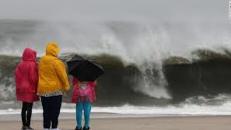
Enlarge Matt Dowling/Times of Trenton A toppled tree damaged units at the Klockner Woods apartment complex in Hamilton, Mercer County Hurricane Sandy Aftermath: Mercer County damage gallery (27 photos)
EWING TWP. — The deaths of a Mendham Township mother and father and an Atlantic City woman are being blamed on Hurricane Sandy, which has left 2.4 million households without power.
“I’ll say to all of you, especially those out there who are facing loss, devastation and the heartbreaking reality that their home may be gone, we are with you,†Gov. Chris Christie said in a public briefing from state police Regional Operations Intelligence Center.
“We have a long road ahead of us but I have complete confidence we’re going to come out of this better and stronger than before. This state is too tough to give in to this type of devastation. We in the government will work with you to have New Jersey completely recovered.â€
As he has throughout the storm, the governor talked to President Obama again last night at midnight. He expedited the state’s designation as a major disaster area.
Christie said it’s too early to put a dollar figure on the unprecedented and grave damage to New Jersey, but he may know more after a helicopter tour of the shoreline today. There is no place for the chopper to land on the barrier islands, but plans to touch down in Avalon and Brick.
Though more may be added, Christie said the eight counties that will receive assistance are Atlantic, Cape May, Hudson, Essex, Middlesex, Monmouth, Ocean and Union.
“I think the losses are going to be almost incalculable,†he said on the “Today Show” this morning.
The couple from Mendham Township was killed overnight when they got out of their pickup truck and were crushed by a fallen tree, Christie said. Their 11 and 14-year-old children in their vehicle were injured, he said.
A third fatality occurred Monday when a woman from Atlantic City had a heart attack, Christie said.
Federal, state and local emergency personnel are conducting search and rescue missions in Atlantic City and Moonachie where a tidal surge at Hackensack River overwhelmed a natural berm and caused a flash flood.
Of the residents out of power, 1.2 million are PSE&G customers, 935,000 JCP&L, 195,000 Atlantic City Electric and 45,000 Orange & Rockland. There have been no reports of looting or crime in areas without power.
Christie said he “can’t and won’t†know when power will be restored, but twice the number of households lost power as they did after Hurricane Irene. After the August 2011 storm, electricity remained off for up to 10 days. “We cannot develop at timeframe for restoration until damage assessment is under way,†he said.
Trees are down everywhere. Christie likened the drive from the state police operations center in Ewing Township to the governors mansion at Drumthwacket to “an obstacle course.â€
State and local shelters are housing 5,500 residents and the state is working on opening another shelter at Rutgers Athletic Center. In addition to FEMA and the National Guard, the Red Cross is offering support services, including mobile meals.
Christie said 91 health care facilities lost street power, including 29 hospitals. The state Health Department requested 100 ambulances from FEMA.
Most roads are reopened, including the entire length of the Garden State Parkway. But Christie cautioned people to “avoid travel unless absolutely necessary.†He advised private businesses to let employees stay home unless owners can identify a safe route to get them to work.
In Carteret, a tidal surge picked up 24 small rail cars and deposited them on to the northern outer roadway of the New Jersey Turnpike. Cranes were dispatched to remove the cars.
Lavallette, Ortley Beach, Seaside Heights and Seaside Park are nearly completely underwater, Christie said. Water carried houses out into the middle of Route 35.
“Am I going to see something worse further south? I don’t know,†he said. “That’s the place I’ve gone to the shore my entire life… I didn’t expect to see homes off their foundationsâ€
Rides from the amusement piers in Seaside Parks were washed out to the ocean as well, he said.
“The level of devastation at the Jersey Shore is unthinkable and we know that there are many people who own homes who we’ve evacuated will want to get back on the island to assess the damage to their homes,†he said. “We are no where near being able to let you back on the island.â€
Jenna Portnoy/Statehouse Bureau By Jenna Portnoy/Statehouse Bureau
on October 30, 2012 at 12:12 PM
- Published in In the News
Sandy Storm likely to shut at least two New Jersey nuclear reactors

(Reuters) – At least two major New Jersey nuclear power plants are likely to shut on Monday as Hurricane Sandy makes landfall as a Category 1 storm and more plants could reduce power as the storm triggers precautionary safety measures.
In Connecticut, Dominion Resources Inc already reduced the output of its Millstone 3 reactor from full power to about 75 percent as a precaution due to high water levels caused by Sandy, the U.S. Nuclear Regulatory Commission (NRC) said.
Sandy, centered over the Atlantic Ocean about 175 miles southeast of New York City, was expected to hit near Delaware and south New Jersey later Monday as a Category 1 hurricane with winds of up to 90 miles per hour.
The nuclear reactors in Sandy’s current path include units at Public Service Enterprise Group Inc’s 2,332-megawatt (MW) Salem and 1,161-MW Hope Creek plants in New Jersey, which were likely to bear the brunt of the storm before it moves inland. Those PSEG reactors combined account for about 19 percent of the state’s total electric capacity, although New Jersey also draws supplies from the whole Pennsylvania, New Jersey, Maryland (PJM) power region.
PJM is the biggest power grid in the United States serving more than 60 million people in 13 U.S. Mid-Atlantic and Midwest states and the District of Columbia.
Electricity traders said if Sandy continues on her expected path it was likely PSEG would have to shut the Salem and Hope Creek reactors later Monday, but they were mixed on whether the storm’s winds would still be strong enough to force the shutdown of reactors in Pennsylvania and Maryland.
PSEG spokesman Joe Delmar said the company would take the Salem and Hope Creek reactors offline if wind speeds reach greater than 74 miles per hour onsite for more than 15 minutes or the river water level reaches 100 feet. Sandy’s maximum winds were at 90 mph earlier on Monday.
The mean river water level at the Salem-Hope Creek site was 89 feet and the site grade was about 102 feet. The highest river level ever recorded was 97.5 feet, Delmar said.
But Sandy was expected to lose some punch as she moves over Pennsylvania and Maryland, crossing near Constellation Nuclear Energy Group’s 1,705-MW Calvert Cliffs nuclear plant in Maryland, Exelon Corp’s 2,244-MW Peach Bottom, 805-MW Three Mile Island and 2,264-MW Limerick in Pennsylvania, and PPL Corp’s 2,450-MW Susquehanna in Pennsylvania.
All U.S. reactors have procedures that require operators to shut the units when hurricane-force winds reach their sites or when floodwaters reach certain levels.
Nuclear power represents about 18 percent of the generating capacity in the U.S. Mid-Atlantic region. One megawatt powers about 1,000 homes.
A few reactors in the area were already shut for refueling or other maintenance, including Exelon’s Oyster Creek in New Jersey, PSEG’s Salem 2 in New Jersey, PPL’s Susquehanna in Pennsylvania and Dominion’s Millstone 2 in Connecticut.
Both Salem Unit 1 and Hope Creek were at full power Monday morning and the refueling work on Salem Unit 2 was suspended by 6 p.m. EDT Sunday, Delmar said.
WIND AND FLOOD WATER
Delmar said only essential personnel were required to report to the Salem and Hope Creek site on Monday.
He said PSEG was in Phase 2 of its severe weather plan.
Phase 1 included inspecting, removing and securing objects outside that could become airborne and putting emergency equipment and supplies in place.
Phase 2 of the plan includes visual inspections of equipment, verifying weather tight doors, checking on emergency diesel availability, and ensuring water intakes are prepared for severe weather.
Power companies from North Carolina to Maine have been preparing for Sandy for days and urged customers to be ready for the possibility of days without electricity. More than 700,000 homes and businesses were already without power Monday afternoon.
The Long Island Power Authority, which serves 1.1 million people on Long Island, New York, and others said outages could last as long as seven to 10 days.
IRENE ALSO SHUT NUCLEAR PLANTS
The last big storm to hit the U.S. East Coast was Hurricane Irene in 2011, which made landfall in the Outer Banks in North Carolina as a Category 1 storm. Irene caused billions in property damage as it ran up the coast from Carolinas to Maine.
Irene left more than eight million homes and businesses without power, some for a week or more in the hardest hit areas. It forced many power plants to shut, including at least two reactors, at Oyster Creek in New Jersey and Calvert Cliffs in Maryland.
Several other reactors had to reduce power primarily due to debris in their cooling water intakes and other reasons, like Duke Energy Corp’s Brunswick in North Carolina, Dominion’s Millstone in Connecticut and PSEG’s Salem in New Jersey.
October 29, 2012|By Scott DiSavino | Reuters.
[representyouinsurancepolicies] [footer1]- Published in In the News
East Coast Prepares for the Storm
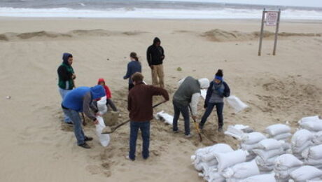
 When people in New York, New Jersey, and Pennsylvania hear about a hurricane, they don’t seem to think anything of it. They actually makes jokes and say that they have their movies and snacks and flashlights. The severity of a hurricane does not cross their minds because unlike people who live in Florida, Georgia, Texas, and other southern states that are used to hurricanes, they really don”t realize what this hurricane can do to them. Hurricanes, especially Hurricane Sandy, is a “megastorm.” The national weather channel predicts that the storm will make landfall by Tuesday. Sandy is supposed to make landfall in Ocean City, which is the most densely populated area containing 64 million people. Last year hurricane Irene caused only power outages to 6 million people in its path and this storm is definitely going to cause more. Many homes will not be able to withstand the impact of the strong winds and flooding. Most homeowners will not how to respond to type of extreme impact to their homes. You can always check on our site for the latest updates and news. Call All American Public Adjusters if your home is damaged from the winds and flooding. We are experienced in property damage claims and understand how difficult a time this may be for you. If you happen to be in the Atlantic City area, the flooding has already begun. Contact us if you have any questions. Our team of adjusters are licensed and bonded in Pennsylvania, New York, New Jersey. We are here to help 24-7. Contact us today at 800.501.1230.
- Published in Blog
During a Storm
1. Stay Indoors, ideally in a rooms without windows that could be broken
2. Use flashlights in the dark if the power goes out. Do NOT use candles.
3. Don’t walk on beaches, riverbanks or in flood waters.
4. Continue listening to local area radio, NOAA radio or TV stations for the latest information and updates.
[representyouinsurancepolicies] [footer1]
- Published in Blog
How to Prepare for Hurricane Sandy

 Right before the storm – Be Prepared:
1. Know the difference between a Hurricane Watch and a Hurricane Warning
-A Watch is when hurricane conditions are threat within 48 hours;
-A Warning is when conditions are expected with 36 hours.
2. Listen to local area radio, NOAA radio or TV stations for the latest information and updates
-NOAA Weather Radio is a nationwide network of radio stations broadcasting continuous weather information directly from the nearest National Weather Service office on the VHF public services band, requiring a compatible receiver or scanner, as they cannot be heard on a simple AM/FM radio receiver.
3. Be prepared to evacuate at a moment’s notice.
-Review your family’s plan with all household members, which should include your evacuation route and destination.
4. Check emergency kit and replenish any items missing or in short supply. Keep it nearby.
-Fill your car’s gas tank
-Turn off propane tanks and unplug small appliances
-Bring inside anything that can be picked up by the the wind (bicycles, lawn, furniture)
-Close windows, doors, and hurricane shutters
-If you don’t have hurricane shutters, board up all windows and doors with plywood.
(Do not tape glass. Taping does not prevent glass from breakjing and takes critical time from more effective preparedness measures.
-Turn refrigerators and freezers to the coldest setting, and keep them closed as much as possible.
(This will help perishable food keep longer should the power go out)
-Clean and sanitize water-storage containers.
(Clean surfaces thoroughly with soap and water, then rinse)
(For containers, add approximately 1 tablespoon of unscented liquid chlorine bleach per gallon of water to make a bleach solution)
(Close the container and shake the bleach solution thoroughly, allowing it to contact all inside surfaces)
(Keeping the container closed, let the bleach solution stand for 30 minutes, and then rinse with clean drinking water.)
(Allow the container to air dry)
- Published in Blog
Coastal Flooding
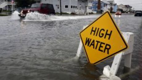
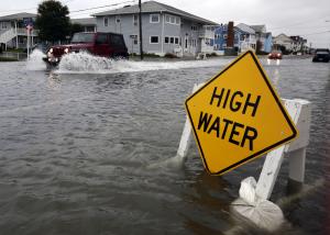 Life Threatening coastal flooding is expected from Monday through Tuesday morning. It is very important that everyone follow the news and make sure that you are in safe areas and prepared for this terrible weather.
As per the National Weather Service. There is currently a Coastal Flood Warning remaining in effect from 6 am Monday to 3 pm EDT Tuesday.
- Locations: along New York Harbor, Newark Bay, the Arthur Kill, The Tidally affected portions of the Hackensack and Passaic Rivers, Long Island Sound, the southern and eastern shores of Long Island, and Tidally affected portions of the Hudson and Connecticut Rivers.
- Tidal departures: between 2 to 3 ft above astronomical Tides tonight during high tide with locally higher values, 3 to 4.5 ft above astronomical Tides Monday morning, and potential for 6 to 11 ft above Monday night into Tuesday morning. The higher end of the range relegated to New York Harbor, western Long Island Sound, the Long Island South Shore back bays, and Peconic Bay.
- High Surf and beach erosion, breaking waves are expected to build to 15 to 20 ft along Ocean facing Shorelines By late Monday into Monday night. The destructive waves on top of the storm surge will cause significant damage to coastal structures nearest to sea level. At the same time, 6 to 12 ft waves are possible along exposed eastern and northeastern facing portions of Long Island Sound, Peconic Bay, and New York Harbor. This is expected to cause major beach erosion and Washovers. This will especially be felt for Fire Island communities such as fair Harbor, Ocean Beach, Cherry Grove, Fire Island Pines and Davis Park.
- Timing: through Tuesday, with the highest storm Tide occurring with the Monday night high tide cycle.
- Impacts: A long duration Coastal Flood event is expected with minor to locally moderate coastal flooding through tonight and moderate to major flooding on Monday, with potential record breaking flooding Monday night into early Tuesday morning. The exact track and timing of the coastal storm will determine the magnitude of coastal flooding Monday night through the Tuesday morning high tide cycle, but the potential is increasing for significant inundation and damage to structures in historically flood prone spots.
NY harbor water levels for Monday morning. Coastal, time of: forecast total, flood. Location, high tide, water level, Category.
[representyouinsurancepolicies] [footer1]
- Published in In the News
Hurricane Sandy is Coming!
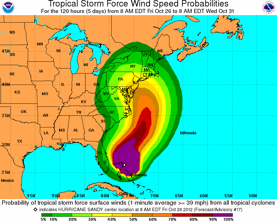
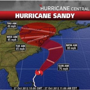
Tens of millions of people along the U.S. East Coast girded themselves on Sunday for Hurricane Sandy, a gigantic storm forecast to assault the densely populated region with battering winds, dangerous flooding and even heavy snowfall.
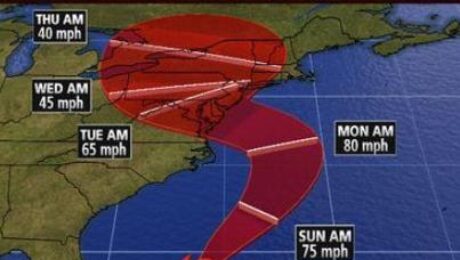
Sandy, expected to come ashore late on Monday, could deliver a harsh blow to major cities in its target zone including New York, Philadelphia, Washington, Baltimore and Boston. Its center was forecast to strike New York-New Jersey area and then move inland toward Philadelphia and the rest of Pennsylvania.
The sheer size of the storm meant its effects would be felt from the mid-Atlantic states to New England. Officials warned of widespread power outages that could last for days.
In New York City, subway, bus and train service will be suspended on Sunday evening and up to 375,000 people were ordered to evacuate from low-lying areas.
President Barack Obama, speaking after a briefing at the federal government’s storm response center in Washington, called Sandy a “serious and big storm” and asked residents to heed the orders of state and local authorities to protect themselves from its onslaught.
“It’s a very, very large system,” National Hurricane Center Director Rick Knabb said. “The storm is going to carve a pretty large swath of bad weather, both water and wind.”
The storm could bring the country’s financial nerve center to a standstill, although the major Wall Street exchanges said they planned to open as usual on Monday because they have alternative facilities they can use.
Worried residents in the hurricane’s path packed stores, searching for generators, flashlights, batteries, food and other supplies in anticipation of power outages.
New York City schools will be shut on Monday. Other local governments also announced school closures.
Gale-force winds were already starting to buffet Virginia and could reach other parts of the mid-Atlantic coast on Sunday night. Tens of millions of people will feel its bluster for as long as two days, Knabb said.
Forecasters said Sandy was a rare, hybrid “super storm” created by an Arctic jet stream wrapping itself around a tropical storm, possibly causing up to 12 inches of rain in some areas, as well as up to 2 feet of snowfall in the Appalachian Mountains from West Virginia to Kentucky.
It could be the largest storm to hit the United States, according to the National Oceanic and Atmospheric Administration’s (NOAA) website.
Sandy was already disrupting transportation systems. More than 700 flights, including international ones, were canceled on Sunday and nearly 2,500 more were canceled for Monday, FlightAware.com said.
CASINOS CLOSE
New Jersey casinos were ordered to close and state officials decided to shut bus and rail systems by early on Monday.
Governors in other states put National Guard troops on alert. “We’re just asking people to be patient and be ready for a long haul. But we have a very aggressive power restoration program in place and I think we’re ready,” Virginia Governor Robert McDonnell told the CNN program “State of the Union.”
In Washington, Obama said officials had assured him that they had all the resources they needed in place, and he stressed that “it is important for us to respond big and to respond fast” to the hurricane’s onslaught.
“We’re going to cut through red tape and we’re not going to get bogged down in a lot of rules,” said Obama, who was having to juggle both is re-election bid and his efforts to stay on top of the storm’s impact just nine days before Election Day.
Sandy blew the presidential race off course, forcing Obama and Republican challenger Mitt Romney to cancel scheduled campaign stops. It fueled fears that the storm could disrupt early voting ahead of the November 6 election.
INSURERS PREPARE FOR STORM
U.S. stock exchanges and Wall Street banks were sending employees into Manhattan on Sunday to stay in hotels and co-workers’ homes, as markets prepared to open for business on Monday even as Sandy brought public transportation to a halt.
Insurers also prepared for the storm’s arrival, activating claims teams, staging adjusters near the locations most likely to be affected and generally getting ready to pay for a potentially huge volume of losses.
While Sandy’s 75 mph winds were not overwhelming for a hurricane, its exceptional width means the winds will last as long as two days, wearing down trees, roofs and buildings and piling up rainfall and storm surge.
Hurricane-force winds extended 175 miles from the center of the asymmetrical storm, while its lesser tropical storm-force winds spanned 850 miles in diameter.
“That’s gigantic,” said Chris Landsea, the hurricane center’s science and operations officer.
At high tide, it could bring a surge of seawater up to 11 feet above ground level to Long Island Sound and New York Harbor, forecasters said.
“Given the large wind field associated with Sandy, elevated water levels could span multiple tide cycles, resulting in repeated and extended periods of coastal and bayside flooding,” the forecasters said.
Sandy was centered about 250 miles southeast of Cape Hatteras, North Carolina, or 575 miles south of New York City at midday on Sunday, the hurricane center said. It pushed seawater up over the barrier islands off North Carolina known as the Outer Banks.
“It’s flooded all over the village,” longtime Ocracoke Island resident Kathleen O’Neal told Reuters. “I would say between a foot and two feet of water.”
Sandy was moving over the Atlantic parallel to the U.S. coast at 10 mph, but was forecast to make a tight westward turn toward the U.S. coast on Sunday night.
Sandy killed at least 66 people as it made its way through the Caribbean islands, including 51 in Haiti, mostly from flash flooding and mudslides, according to authorities.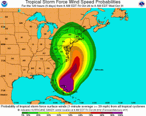
- Published in In the News
Diminished Value

 Getting into a motor vehicle accident when it’s not your fault is a terrible feeling. You have deal with another individuals insurance company to fix your car. They never make it easy on you. Then you get your car back but it will never be worth what it was prior to the accident.
Because your vehicle has a record of being wrecked, that will follow it wherever it goes. If any potential buyer checks with several growing car-history services, they’re not going to be willing to pay as much for it as they would have before it was hit — regardless of how well it’s been repaired.
In the states of Florida, Georgia, Oregon, California, and North Carolina, Kansas, Texas, and Washington the law states that if you are not at fault, you are entitled to recover your vehicle’s lost value from the party that was at fault in all 50 states. If you happen to live in Georgia, Kansas, or North Carolina, you can also collect on diminished value from your own insurance company, even if you were at fault.
An insurance policy states that the insurer agrees to pay for loss to a covered vehicle. Once an insurer elects to pay for the repair of the vehicle, they must return it to like kind and quality. The repairs might have been completed but the vehicle is returned significantly less in value then before the accident.
Because of this, we are now able to collect Diminished value for an insured. The diminished value of a vehicle can be up to 40% of what the vehicle is worth.
If you were not at fault, you are entitled to all costs and expenses caused by the negligence of the at-fault party. Those expenses include:
- All required repairs to restore your vehicle to its pre-damage appearance, safety and function.
- A replacement rental vehicle or payment for loss of use, from the date of the damage until you pick-up your repaired vehicle.
- Payment for any out of pocket expenses such as, police reports requested by the insurance company, mileage expenses to obtain repair estimates, etc.
- Payment for any personal property that was damaged including; child car seats, CDs/cassette tapes, sunglasses, golf clubs, clothing, and any other items that were damages in the accident
- Payment for the diminished value of your vehicle
All American Public Adjusters, Inc has been successful at collecting diminished value for customers that have suffered losses to vehicles and have not been compensated properly by the insurance company. We can help you today. We do not charge ANY UPFRONT COSTS! Call us today for a free evaluation of your vehicle loss. You have nothing to loss.
[footer1]
- Published in In the News
Business Interruption – Time is Money

 When a commercial property suffers a loss such as a fire, hail, windstorm, vandalism, or equipment damage, it is very important to have business income insurance. This type of coverage is not generally sold as a stand-alone policy, but rather an extra policy provision. Business income insurance keeps your business from having to close its doors due to these unexpected events. When a loss happens to your commercial property, you are still obligated to pay the bills such as employees, rent or mortgage payments, advertising, suppliers, taxes, or even yourself. Business income insurance can keep the capital flowing through your company in the event that a loss occurs. It may also help you maintain your business continuity strategy, keep your business afloat if you are required to close for a short time, pay for loss net income and continuing expenses like mortgage, advertising, taxes, and salaries, and pay your relocation and advertising fees if you must set up at a temporary site.
When a loss happens to your commercial property, there is a lot of documentation the must be prepared for your insurance company in order to collect money for this business interruption. On average, property owners do not know where to begin. All American Public Adjusters, Inc is licensed and bonded to review your policy, review and prepare all of your records to present to the insurance company to get you compensated as quickly as possible. Because time is money, it is important to have an expert help you in this time of need. Call All American Public Adjusters, Inc if you have suffered a loss to your commercial property.
[footer1]- Published in Blog, In the News